


UPDATED: Navy Activates Hospital Ship USNS Mercy
WASHINGTON: The US military’s relief effort for the typhoon-ravaged Philippines is ramping up, with four more V-22s on the way from Japan, the USS George Washington carrier group due any time, the amphibious ships Germantown and Ashland en route, and the intelligence community providing highly detailed geolocation data — known to old-timers as maps.
The US relief effort, known to the military as Operation Damayan (according to the Marine website it means “help in time of need” in Tagalog), has delivered 129,000 pounds of relief supplies as of today. The George Washington and three other ships — the cruisers USS Antietam and Cowpens and the oiler USNS Yukon — are due to arrive off the coast of the Philippines the evening of Nov. 14 local time. And the Navy has activated the hospital ship USNS Mercy, based at San Diego. “If ordered to deploy, Mercy would get underway in the next several days and could arrive in the Philippines sometime in December, joining other U.S. Pacific Fleet units already supporting Operation Damayan,” according to an official Navy story just issued.
The food, water and medical supplies have been delivered by KC-130s and the first four V-22s. The aircraft have also ferried 160 people away from the utterly ruined town of Tacloban to Manila and flown in 140 relief workers.
A key enabler of the relief effort has been a rapid response team of 15 workers at the National Geospatial Intelligence Agency (NGA). Formed right after the storm made landfall, the team is “providing damage assessments of key infrastructure, roads and communication networks destroyed in the storm,” Don Kerr, NGA spokesman said this evening in an email. A senior Marine Corps official described NGA’s efforts yesterday as “key” to the military’s planning for and subsequent response to the disaster. NGA takes photos, infrared and other data from satellites (including some imagery from the spy satellite operator, the National Reconnaisance Office) and airplanes and builds them into remarkably detailed and accurate maps.The team is providing USAID and Pacific Command both images and the analysis needed to make the data useful to people on the ground.
NGA has built a web portal for this response similar to the one first launched in the wake of Super Storm Sandy in October 2012, Kerr wrote. The “disaster event page” for Typhoon Haiyan grants access to the information via a password-protected Web page. They can both view and download maps, graphics as well as submit information and ask for new information and analysis. Philippine government officials and government-authorized NGOs can view information through the All Partners Access Network (APAN), an unclassified web portal. So far, no NGA personnel have deployed to the islands and no equipment is being sent, Kerr said.
The model for the NGA response was built during Hurricane Katrina. NGA was pretty much the only government agency to receive high praise for its planning and response to that disaster. During domestic disasters, NGA deploys a truck-mounted system known as DMIGS (Domestic Mobile Integrated Geospatial-Intelligence System).
U.S. Pacific Fleet ships already operating in the Western Pacific were also immediately diverted. The destroyers USS Mustin (DDG 89) and USS Lassen (DDG 82), the submarine tender USS Emory S. Land (AS 39), and oceanagraphic survey ship USNS Bowditch (T-AGS 62) are now on station and coordinating with the Philippine government. The U.S. Navy also has land-based P-3 maritime reconnaissance aircraft already supporting the disaster relief effort led by the Government of the Philippines.
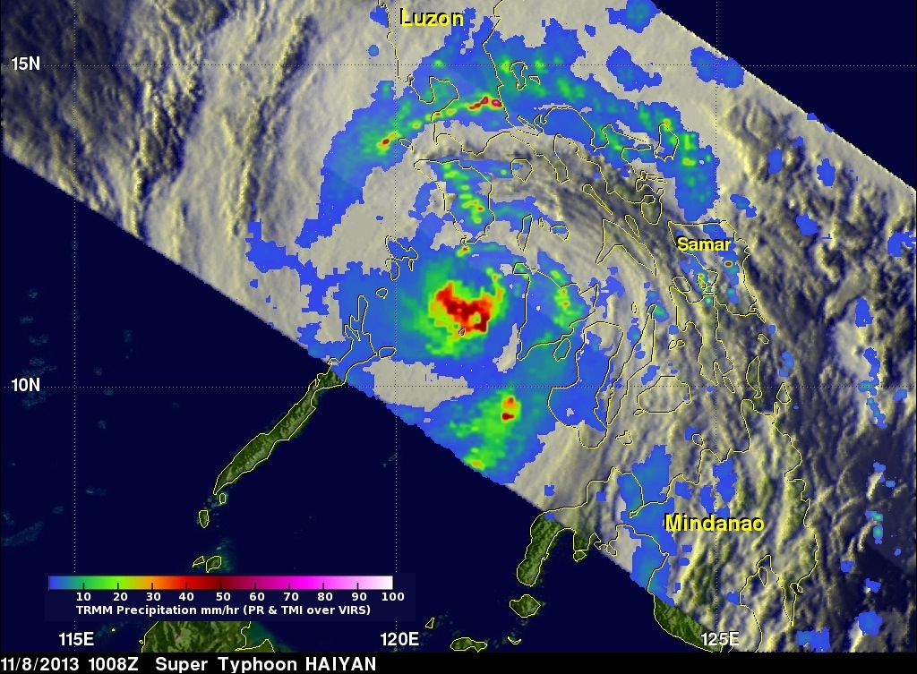
Typhoon Haiyan has affected more than 4.2 million people in the Philippines, their government estimates.

New Army mounted system won’t play favorites when it comes to C5ISR, EW and A-PNT
The CMOSS Mounted Form Factor will facilitate tech insertion for new capabilities while co-existing with the Mounted Family of Computer Systems.
Multi-ship amphib buy could net $900M in savings, say Navy, Marine Corps officials
Lawmakers gave the Navy authorities to ink a multi-ship amphib deal years ago, but the service has not utilized that power yet.