


Spire Global graphic
WASHINGTON: Nanosatellite startup Spire Global didn’t set out to become a provider of signals intelligence (SIGINT). But with the accidental discovery that its antennas for weather forecasting were also picking up signals being used to jam the Global Positioning System, the pivot just made sense, according to Spire’s new-ish head of US government sales, Conor Brown.
“We actually first, sort of, serendipitously discovered this capability when we were calibrating our first reflectometry satellites,” he told Breaking Defense in advance of last week’s annual Space Symposium in Colorado Springs.
“It’s been really interesting to repurpose our weather satellites, and apply them to a completely different mission set,” he added. “And so we’re looking at a lot of future architectures — more purpose built solutions, but also maximizing the capability of our satellites on orbit.”
Detecting interference of GPS satellite signals in conflict zones actually is “low hanging fruit,” Brown explained, because military jammers “are loud — they’re way above the noise floor. We’re picking them up accidentally with our weather satellites.”
More difficult, he noted, is pinpointing low power interference in urban settings. “That’s the holy grail, and something in the longer term certainly we’re interested in — more advanced signal processing to pull out those bad signals.”
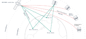
Reflectometry satellites carry antennas that “are pointing straight down at the Earth,” Brown explained, and that technique “measures GPS signals as they bounce off the surface of the Earth as opposed to bending through the atmosphere.” Reflectometry is typically is used to do things like calculate levels of sea ice.
Spire also has sats that carry “radio occultation antennas that are mounted on the side, so they’re looking at the Earth, so that they’re measuring signals as they bend through the atmosphere,” he said, as well as antennas that sit on top of its satellites to catch undisrupted GPS signals.
Spire Global’s CubeSat network, Spire graphic
Spire, over the past six months, has demonstrated its ability to ferret out radio frequency interference in a few different “federal government” exercises, Brown said, though he didn’t want to provide any details.
However, he did acknowledge that the company, headquartered in Virginia, now is seriously eyeing both the DoD and Intelligence Community markets.
Both the National Reconnaissance Office (NRO) and the National Geospatial-Intelligence Agency (NGA) have expressed interest in the ability to use what is often called geolocation to pinpoint jammers, as well as to find other sorts of targets by following their radio frequency broadcasts. NRO is in charge of buying commercial remote sensing imagery to meld with information gathered by spy satellites; NGA gathers up natsec and commercial imagery data and analytics to provide high-quality maps and other products to the IC, DoD and other government agencies.
Spire currently has 120 teeny CubeSats in Low Earth Orbit between 350 and 650 kilometers in altitude, and Brown said the firm has another batch slated to launch in December on a SpaceX Falcon 9. (The smallest CubeSats are 10X10X10 centimeter units, called 1U; while they can be scaled up, they typically weigh less than 1.33 kilograms, or three pounds.)
The company earlier this month went public via a merger with NavSight Holdings, a Special Purpose Acquisition Company, or SPAC, designed to take startups onto the stock market. It also just won its first funding for RF geolocation, from the UK Defence and Security Accelerator (DASA), London’s space innovation hub.
And today, Spire announced a new six-month contract, for an unspecified dollar amount, with the National Oceanic and Atmospheric Administration (NOAA) under the Commercial Weather Data Buy Program. NOAA will buy the firm’s commercial radio occultation weather data.

BAE Systems’ LR-PGK: The Superior Anti-Jam Solution
Going the distance to defeat emerging jam threats.
Space Force EW unit working to integrate new weapon systems, intel personnel
The Space Force’s Delta 3 is responsible for organizing, training and equipping Guardians for electronic warfare missions involving satellite communications, as well as sustaining related offensive and defensive EW systems.