UPDATED 9/4/23 with quotes from analyst Meia Nouwens.
SYDNEY — Waves of anger spread across the South China Sea and India this week, following China’s publication of a new official map renewing its illegal claims to most of the sea and adding new claims along the Indian border.
China’s latest hegemonic behavior appears in the form of what it calls the “new standard” map, published by China’s Ministry of Natural Resources on August 28. The new map repeats the 9 Dash Line claims made by China and rejected by the United Nations’ Law of the Sea tribunal, while also claiming new territory around Taiwan and to Inda’s north. This comes days after President Xi Jinping declared at the latest BRIC summit that “hegemonism is not in China’s DNA.”
The biggest furor arose, unsurprisingly, with India, where China has unilaterally claimed two new areas, angering both India and Nepal. But India is not alone.
“Most of the contention seems to be that it claims Indian territory – Arunachal Pradesh and Aksai Chin – as Chinese territory, but it also claims some territory of Russia [Bolshoy Ussuriysky Island], as well as the entirety of the South China Sea and Taiwan,” Malcolm Davis, an Indo-Pacific expert at The Australian Strategic Policy Institute in Canberra.
“I believe there is also some suggestion that the way the dashes are drawn near Taiwan could indicate that China also sees Japanese islands in the Ryukyus as its territory. China had claimed the Indian territory, as well as South China Sea and Taiwan previously, but the re-assertion of claims to Russian territory and also the potential for claims to Japanese territory are new,” Davis said in an email. “The Indians have reacted angrily and formally protested the Chinese move, and Japan will certainly seek clarification on China’s intentions. Not sure how Russia will respond, given that Moscow needs Beijing’s support in the Ukraine war.”
As often happens with issues of sovereignty in the Indo-Pacific, different experts offered differ perspectives on what’s actually happening. Asked if the new map includes new claims, Ian Chong, associate professor at the National University of Singapore. said the “claims are not new, although the timing is surprising.
“Perhaps it may have to do with the Philippines and Vietnam publicizing use of water cannon by PRC vessels to block their vessels,” Chong continued. “Perhaps it may have to do with Vietnam and India moving to side with the 2016 arbitral tribunal ruling about the lack of islands in the South China Sea, which by extension means that features Beijing occupied cannot generate expansive claim. But all this is speculation. There remains no official explanation as yet. Then why bring in Russia?”
Its publication, argued Meia Nouwens, a Chinese expert at the International Institute for Strategic Study in London, should be viewed as an example of Chinese lawfare.
“The Chinese government has in recent years changed domestic laws to provide its law enforcement and military agencies greater legal right to defend Chinese territorial claims in the region,” she said in an email. “The PRC has published its map ahead of the G20 and ASEAN summits, both to be held in September. By publishing the map now, the PRC seeks to double-down on its territorial claims and signal that it is determined to enforce them.”
Local Reactions
The new map sparked sharp reactions from India, Nepal, Vietnam, Malaysia and Taiwan. The new document was released one week before the G-20 summit in India, where Xi was to attend but news reports now indicate he will not.
India lodged “a strong protest through diplomatic channels with the Chinese side on the so-called 2023 ‘standard map’ of China that lays claim to India’s territory,” Arindam Bagchi, a spokesman for India’s External Affairs Ministry, said Wednesday in a statement. “We reject these claims as they have no basis. Such steps by the Chinese side only complicate the resolution of the boundary question.” Indian and Chinese troops have killed each other repeatedly in border battles over the two areas claimed by China, with the first fighting happening in 1962.
“Malaysia does not recognize China’s 2023 standard map, which outlines portions of Malaysian waters near Sabah and Sarawak as belonging to China,” the foreign ministry said in an Aug. 30 statement.
A day later, the Philippines Department of Foreign Affairs issued a statement that it “rejects the 2023 version of China’s Standard Map… because of its inclusion of the nine-dashed line (now a ten-dashed line) that supposedly shows China’s boundaries in the South China Sea … This latest attempt to legitimize China’s purported sovereignty and jurisdiction over Philippine features and maritime zones has no basis under international law, particularly the 1982 United Nations Convention on the Law of the Sea (UNCLOS).”
China’s Foreign Ministry Spokesperson Wang Wenbin said at a regular press briefing Aug. 30 that “China’s position on the South China Sea is consistent and clear. The competent authorities of China routinely publish standard maps of various types every year, which aims to make standard maps available to all sectors of society and raise public awareness of the standardized use of maps. We hope parties concerned can view it in an objective and rational light.” The day before, Wang responded to India’s protest in similar fashion, with a touch more condescension: “We hope relevant sides can stay objective and calm, and refrain from over-interpreting the issue.”
The language here bears an intriguing relationship to that used by the head of the Peoples Liberation Army at this year’s Shangri La Dialogues in Singapore. Gen. Li Shangfu told the world to “mind your own business” when asked why China’s military frequently engaged in dangerous and unprofessional behavior in the East and South China Seas when other nations militaries were in international waters.
This latest map puts the official stamp on China’s 10-Dash Line, an upgrade from the old 9-Dash Line. But the map should be seen within the context of efforts by the Chinese Communist Party to change it over time, said Nouwens.
“With regards to Taiwan, the map differs in the sense that it adds a 10-th dash. The nine-dash line has become a 10th dash line. But this isn’t new!” Nouwens said in her email. “The original map that the nine-dash line claim was based on was created by the National government of the Republic of China in 1947, prior to the [Chinese] civil war. After the Communist victory, the PRC has used the map to lay claim to vast swathes of territory in the South China Sea and around Taiwan.
“However – the original 1947 map was actually an 11 dash map. In 1953, the PRC removed two dashes in the Gulf of Tonkin as part of an agreement with the government of Vietnam, this left 9 dashes on the map.” And now we have 10 again,” she explained.
Of course, the UN tribunal ruled that the China’s earlier claims had no validity in international law and that China’s claims to the territories ascribed were unfounded in law or history.
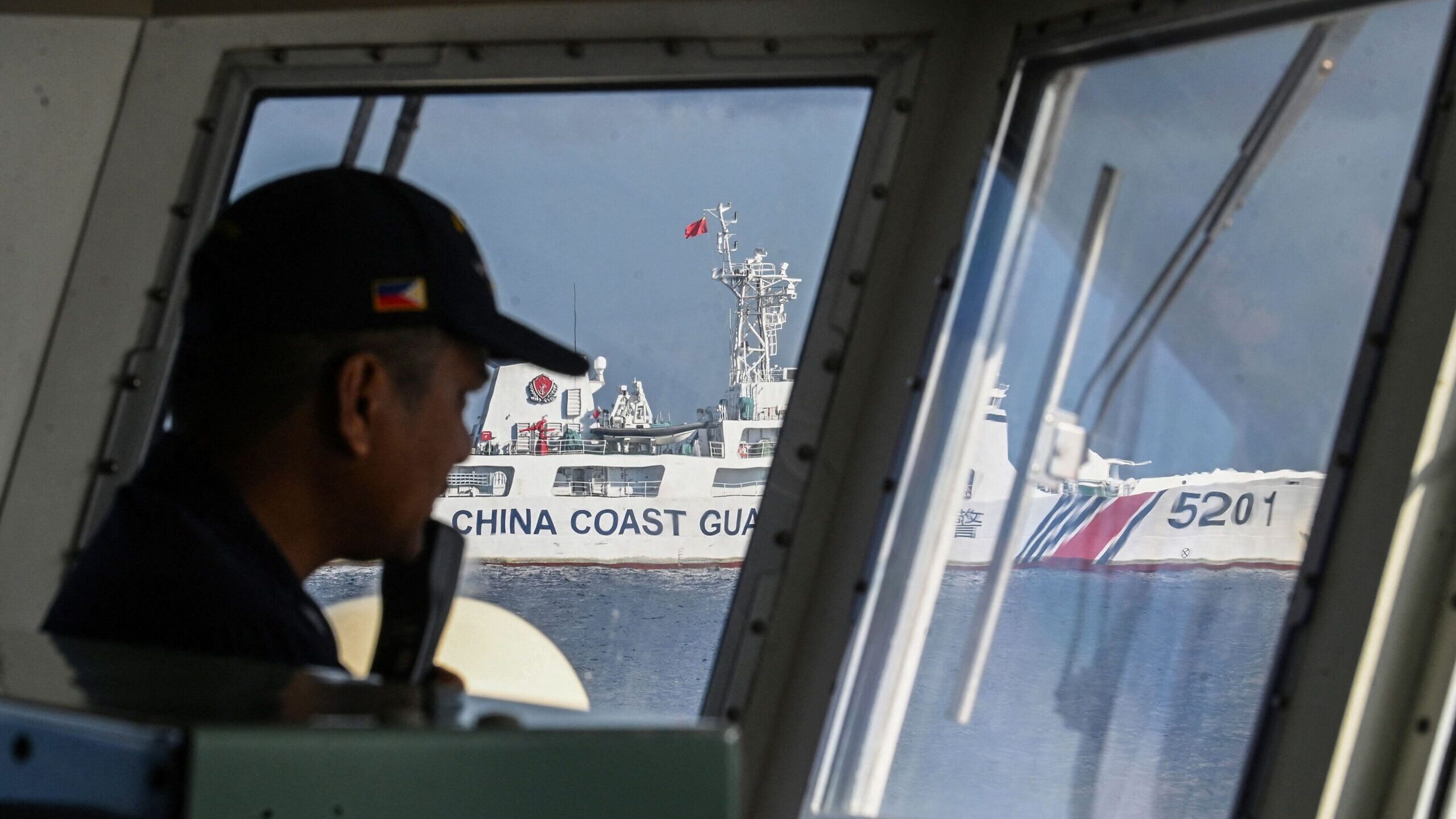
Since then, China has destroyed some of the world’s most pristine coral reefs to build naval and air bases to try and cement its claims, fired water cannons at and lazed crew of small Philippine vessels trying to resupply troops on a reef within its Exclusive Economic Zone, threatened the USS Chung-Hoon as it and a Canadian ship, the HMCS Montreal made a rare joint transit of the Taiwan Strait, and performed a raft of other belligerent and sometimes dangerous maneuvers around other nations ship and US military aircraft — all of them operating in international domains.
Palau Welcomes US Coast Guard
In a noteworthy bit of timing, the Pacific island state of Palau inked an agreement Aug. 23 with the US Coast Guard letting the red and white ships sail in the Exclusive Economic Zone on behalf of Palau, without a Palauan officer present.
“This agreement helps Palau monitor our exclusive economic zone, protect against Illegal, Unreported, and Unregulated fishing, and deter uninvited vessels from conducting questionable maneuvers within our waters,” President Surangel Whipps said in a statement.
RELATED: US touts $810M for Pacific islands to help fend off China, some for Solomons
Palau relies on the United States for its defense, as do some of the other Pacific states, which raises the question of whether this agreement could become a model for some of the smaller Pacific nations to follow. If so, the Marshall Islands and Micronesia “could be candidates, Mihai Sora of the Lowy Institute, an independent think tank here, said.
“But Pacific States, like all countries, are highly sensitized to incursions on their sovereignty, and it’s hard to imagine too many banging on America’s door asking for a similar agreement at this stage,” Sora added. “The US still has a lot of diplomatic groundwork to cover in its relations with Pacific Island Countries before it could float such an idea.”
More fundamentally, would such patrols, which are clearly aimed at discouraging the vast Chinese fishing fleet and China’s Coast Guard from entering the EEZ, help to lower or heighten tensions in the region?
“The US would argue that providing increasing security assistance to a small island nation like Palau helps to reinforce the rules-based order and the regional balance of power. But many Pacific nation figures have argued the opposite – that increased securitisation of their region does increase the risk of conflict,” Sora said in an email. “In this case, it appears that Palau has explicitly asked for this kind of support from the US.”