WASHINGTON: ICEYE, a small Finish startup operating a constellation of synthetic aperture radar (SAR) micro-satellites, has big hopes for sales of high-resolution Earth images to the Defense Department and other federal government customers.
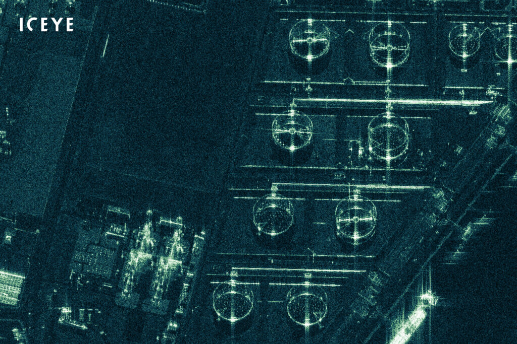
The firm announced today it is now selling 25cm resolution SAR images, Until recently, only much larger SAR satellites operated by prime contractors for government customers could provide such resolution. ICEYEs micro-satellites weigh in at under 100 kilograms. The company was the first to launch a SAR micro-sat, in January 2018.
SAR satellites provide the ability to see through clouds, day and night — a capability much desired by intelligence agencies, as well as civil space agencies. As Breaking D readers know, the US for several years has been grappling with how to handle the proliferation of commercially available SAR imagery. It’s been an especially difficult issue because most of the imagery emanates from non-US providers. In the US, there have been long-standing sales restrictions due to concerns about undercutting the National Reconnaissance Office’s technology edge. As I reported, the NRO in December awarded its first contract to study the possibility of using commercial SAR imagery to US start-up Capella Space.
ICEYE’s CEO for its US arm, ICEYE US Inc., Mark Matossian answered Breaking D’s questions via email this morning about the new imagery, its customers and its plans.
Do any other company’s sell 25cm SAR images?
“There are traditional, over 10-times larger SAR spacecraft that have achieved this type of data, including TerraSAR-X from Europe. Commercial availability worldwide for this type of fine resolution data is very limited.”
Empower defense teams to scale AI securely
AI is expanding the mission data footprint across defense environments, increasing the need for scalable, layered data-at-rest (DAR) protection.
Do you have any contracts with DoD or other USG agencies? If not, do you see NRO or NGA or Space Force as customers, or are US regulatory issues a problem?
“We do have partnerships with USG agencies, but as with most commercial and government data customers, we don’t typically disclose further information about these relationships. One publicly disclosed data customer has been DIU [DoD’s Defense Innovation Unit] already in 2017, so ICEYE has been active on this front for a long time.
“We think there is a tremendous demand within the US government for this type of high quality SAR data, so we’re eager to broaden and deepen those engagements. There are needs related to tipping & queuing capabilities to combine the efforts of commercial and national assets, as well as needs for sensor fusion with other data types. What’s important for ICEYE is to provide our customers a data-rich environment, for them to then be able to make more informed decisions when it matters most.
“ICEYE is deeply committed to the US SAR market. We are continuing our active work towards FOCI Mitigation, potential US manufacturing, and deepening our processes in alignment with US cybersecurity standards, and other USG customer needs. For clarity, plenty of ground has already been covered, as ICEYE has had commercial SAR data globally available since 2018.”
(FOCI Mitigation is the process by which a foreign owned or controlled firm can be awarded a security clearance.)
How many satellites are in your current constellation, and how many are planned in full constellation by when?
“We have three commercially available SAR satellites in-orbit, with further multi-satellite launches manifested for this year, which will more-than-double the commercial constellation during 2020. ICEYE will continue to fill out the constellation for both capacity and high revisit times as the commercial and government markets require.
“As ICEYE controls the full chain from instrument design, to manufacturing, to operating satellites, to processing data, we can — and do launch — new spacecraft to support large customers based on their requirements. The main driver for how many spacecraft would be in a full constellation is based on the customer need. We’ve brought down the manufacturing timescales of these units from years to months, and are currently serving operational customers with a three spacecraft SAR satellite constellation.”
(While Matossian was loathe to lock the company down on the ultimate size of its constellation, the European Space Agency, which since 2019 has been studying possible acquisition of ICEYE imagery, reported that at that time the firm intended to have at least 18 satellites by the end of 2020.)
Besides the US, which other governments are looking at using your imagery for national defense purposes?
“[W]e’ve been very pleased with the response from multiple governments on a global basis. Some of those are commercial in nature or even environmentally focused. Of course, there are several types of needs from government agencies that we serve based on the exceptional resolution, and day/night, all weather capability of SAR.”
Are you selling just imagery or analytics as well?
“We are selling imagery, ground station services including immediate data processing, value-added analytics, and full spacecraft missions. As an analytics example, we service customers with AI-powered maritime vessel detection on ICEYE SAR data, which is then combined with commercial AIS [automatic identification system] data, to identify so-called “dark vessels” that do not have their AIS transponders turned on. This is done for the appropriate agencies to then secure the safety of their coastal areas, and beyond.
“Importantly, we are building a rich ecosystem of US analytics partners that are extending the power of our imagery data with their own excellent analytics capabilities. These already include excellent work from Ursa Space and RS Metrics. In the long run, it’s the partner ecosystem that will provide a deep and diverse suite of analytic options for the US market, powered by ICEYE SAR data.”
NOTE: The National Geospatial-Information Agency (NGA) has been under an exploratory agreement for analytic services with Ursa Space, which is positioning itself as an analytics provider and middleman between SAR satellite operators and customers.