WASHINGTON — The National Geospatial-Intelligence Agency (NGA) is gauging industry interest and capabilities to update its Stardust program that develops models of the Earth used for matching GPS coordinates to locations on the ground, as well as other types of mapping.
The effort includes migration of what currently are stovepiped, mission-specific models to the cloud, according to NGA’s recent request for information (RFI).
“The purpose of the Stardust program is to provide Earth Modeling capabilities,” an NGA spokesperson said in an email. “Stardust will result in the modernization of Geomatics IT systems and infrastructure. As part of this modernization, the program will provide assessment, engineering, and micro-services development to optimize both the systems and the intended cloud environment.”
Geomatics is the science of collecting, analyzing and interpreting data relating to the Earth’s surface — such as elevation and gravity.
Stardust is run by NGA’s Foundation GEOINT Integrated Program Office, partnered with the Foundation GEOINT Group (NGA/SF) within the Source Operations and Management Directorate. “NGA/SF is responsible for providing foundational content and services associated with a variety of NGA’s mandated missions, including Safety of Navigation and military planning/operations support,” according to the RFI.
Within NGA/SF, the Office of Geomatics is responsible for developing and maintaining standards, capabilities and services for various types of modeling used by the Department of Defense for positioning, navigation, timing and targeting, as well as other sorts of mapping (for example, of terrain including elevation).
According to NGA’s “performance of work statement for Stardust base requirements” [PDF], these models include:
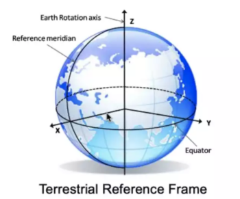
- The World Geodetic System 1984 (WGS 84), which underpins most global Positioning, Navigation, and Timing (PNT). WGS 84 consists of a Terrestrial Reference Frame (TRF), Earth Gravitational Model (EGM), and World Magnetic Model (WMM). (A TRF uses longitude and latitude measurements, for example gathered by GPS, to allow a user to compute their position at any time and location and compare it to others around the world.)
- Digital Elevation Models (DEMs), point clouds, and other 2D, 2.5D, or 3D content types utilized in mission planning, space awareness, and targeting applications.
- The Global Positioning Satellite (GPS) system and Global Navigational Satellite System (GNSS) data provisioning, analysis, and modeling such as Earth Orientation Parameters (EOP) and Precision Timing.
Stardust is aimed modernizing the models themselves and the software systems for utilizing them.
“The desired end-state architecture will have all these systems migrated to modern, cloud-based provisioning environments while using DevSecOps approaches, service-oriented architectures, modern code management tools, and current programming languages,” according to the requirements statement.
NGA is seeking industry assistance both with “Platform Services” to transition modeling capabilities to the cloud, and “Applications Services” to design and development new applications software for assured positioning, navigation, timing and targeting; safety of navigation; and “Target Coordinate Mensuration (TCM), which relies on Elevation (DEMs), Precise Imagery, and geopositioning data.”
Interested industry has until Dec. 21 to respond to the RFI.