
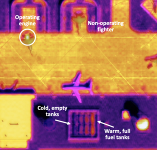
WASHINGTON — Barely two years after its founding, Colorado startup Albedo has caught the attention of Space Force intelligence pros with its promise of satellite imagery at a level of detail rivaling that taken by surveillance aircraft — allowing, for example, an analyst to easily count aircraft at an airbase, and even tell which ones have hot engines.
Albedo today announced that it has scored its second Direct to Phase II Small Business Innovation Research (SBIR) grant from the Department of the Air Force’s AFWERX commercial innovation hub, bringing Pentagon investment in the firm up to $2.5 million.
“Our satellites will collect both 10 centimeter optical imagery and two meter thermal long wave infrared imagery. Both have the highest resolution in their respective regimes, and they’ll collect them simultaneously so you can fuse them together and do a bunch of cool stuff … to add extra intelligence,” CEO and Co-founder Topher Haddad told Breaking Defense in an interview.
The company boasts that it was the first to receive a license to sell such ultra-high resolution imagery from the Commerce Department’s National Oceanic and Atmospheric Administration, which regulates US remote sensing firms. Until 2020, sales of 10cm satellite imagery — which is equal to that provided by the sophisticated, multibillion spy satellites operated by the National Reconnaissance Office — was prohibited.
Haddad, a former Lockheed Martin satellite engineer, explained that the impetus for the creation of the company came in 2020 when he stumbled upon a news article about then-President Donald Trump’s tweet of a 10cm image taken by a classified spysat.
“It sparked this conversation in the commercial industry around what you could do with 10cm resolution imagery. If you had that commercially, it would be game changing. It would unlock all these use cases that you need drones and planes for today,” he said. “But everyone concluded it would cost over $1 billion per satellite. So, it just wouldn’t make sense to do commercially.”

How the Pentagon is shaping its next cyber strategy
Drawing on Breaking Defense's TechNet Cyber 2026 coverage, this eBook examines how the Pentagon is advancing AI, cybersecurity, and cyber strategy to strengthen the future force.
However, Haddad — and his co-founders Winston Tri, a former Facebook software engineer, and AyJay Lasater, a former Lockheed Martin satellite engineer — figured that they could get the costs way down in one simple way: by flying satellites very close the Earth.
“You could design this constellation of essentially VLEO, very low Earth orbit, flying satellites that collect that resolution at orders of magnitude cheaper, just based on the sheer drop in aperture size” required at such altitudes, Haddad said.
VLEO is generally defined as between 250 and 450 kilometers. Today, most satellites use higher orbits because the closer a spacecraft to the Earth, the more often it must use its onboard engines to keep in place due to gravity’s tug. Albedo, however, is using electric propulsion to keep its refrigerator-sized satellites up, Haddad explained.
“[E]lectric propulsion makes the fuel on your satellite much more efficient at the expense of low thrust. But for an imaging mission, you don’t need high thrust if you’re just station keeping. There’s a lot of time that you’re actually imaging that you can you can stay up in the atmosphere,” he said.
Haddad added that the larger size of Albedo’s birds also is a key factor in making VLEO viable for the firm’s operations. “Mass is one of the subtle ones that I think a lot of people don’t realize. In that you can’t do this with a CubeSat, a CubeSat will fall out of the sky very quickly,” he said.
Pentagon Dollars
The firm’s first $1.25 million Direct to Phase II award, which Haddad said was made last summer, was to evaluate how the satellites and their two sensors working together potentially could support a number of government intelligence, surveillance and reconnaissance (ISR) use cases.
Under the new grant, also worth $1.25 million, the company will demonstrate to the National Air And Space Intelligence Center (NASIC) its nighttime imagery chops using the thermal infrared sensor.
NASIC, headquartered at Wright Patterson AFB in Ohio, provides the Defense Department with intel about potentially threatening adversary scientific and technical advances.
“Nighttime commercial imagery is currently limited to synthetic aperture radar,” said Joseph Rouge, US Space Force Deputy Director, Intelligence, Surveillance, and Reconnaissance in a statement for Albedo’s announcement today. “High-resolution thermal infrared will provide a new commercial remote sensing solution for the US Space Force.”
Haddad explained that “a big part” of the second SBIR effort will be an aerial demonstration.
“So, we’ll be flying the flight sensor, demonstrating at nighttime what the thermal imagery will look like and what the performance will be. We’ll be doing some lab characterization to really increase the fidelity and make it representative of what we’ll get from space,” he said.
Albedo hopes to launch the first of its six satellite constellation “in about two years,” Haddad said, which will give it a revisit rate over any one spot once a day. Ultimately, the company is aiming for a constellation of 24 birds, allowing passes five times a day.
Once a full constellation is up, that opens the potential for Albedo to help the Space Force with one of its other top priorities — the capability to track moving targets on the ground in combat-relevant timeframes.
In its 2024 budget request, the service for the first time formally asked for funds, some $234 million, to formally initiate a joint effort with the Air Force and the Intelligence Community to develop a ground moving target indicator (GMTI) for satellites.
While Haddad said Albedo’s satellites are not optimized for that mission, he explained that they might have some capacity to contribute.
“We’re looking at ground moving target indication,” he said. “There’s better ways to utilize our constellation than that, but we can provide capability for a subset of GMTI use cases.”