SPACE AND MISSILE DEFENSE SYMPOSIUM: America’s adversaries — and the general public — will soon be able to watch US troop movements, top secret weapons development and testing facilities (think Area 51), missile launch sites and nuclear laboratories as radical transparency is enabled by the nexus of commercial remote sensing, Artificial Intelligence (AI) and 5G networks, a new study by the Aerospace Corporation concludes.
The study, obtained by Breaking Defense, posits a not-so-far-off future dubbed the “Geospatial Intelligence (GEOINT) Singularity” where “realtime Earth observations with analytics are available globally” to everyone including the average citizen. This will be made feasible by the convergence of the trends in “global connectiveness, commercial remote sensing from space, and advances in artificial intelligence (AI),” which “point toward a future where information and overhead imagery will become available to the general public in near realtime.”
The study, authored by Josef Koller, former senior advisor on space policy to the Office of the Secretary of Defense, cites the “rise of large constellations with remote sensing satellites and capabilities ranging from synthetic aperture radar imaging, nighttime imaging, and infrared imaging” coupled with AI analytics that allow “data from different sensors can be combined, processed and made useful for a specific user’s needs on handheld devices worldwide” as creating a “nowhere to hide” scenario on Earth.
The enabler for all this will be 5G wireless communications that “will provide the data pipeline needed to reach users globally at broadband speeds.”
The study notes that the opportunities for civil, commercial and even military uses are tremendous — think about the US being able to track road-mobile nuclear missile launchers in Russia and China without interruption.
Europe’s military advantage depends on sovereign command of the ground truth
As NATO and European governments accelerate investment in space-based intelligence, decision advantage will depend on how quickly sovereign and commercial capabilities can be fused into a trusted operational picture.
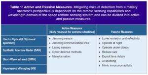
On the other hand, the downsides of “the availability of ubiquitous, realtime intelligence” are just as formidable for US military planning and operations. Risks to US national security from such developments are almost infinite, the study finds. “[A]dversaries could track the movements of U.S. and allied military equipment, detecting patterns of training and operations; hyperspectral imaging can identify chemical compositions; short-wavelength infrared imaging can see through clouds; and SAR sensors can image at night. When determining risks to national security, one can define it as the risk of being seen or detected.”
Despite the risks, the study suggests that the traditional approach of trying to regulate commercial remote sensing to “limit the imagery that can be taken from space” is flawed. For one reason, international capabilities cannot be significantly affected by US export controls.
This is clearly evidenced by US regulations on the domestic and export sales of synthetic aperture radar (SAR) satellites for national security reasons. For many years, the National Reconnaissance Office (NRO) was the only legal customer for such capability. This has resulted in a situation where US companies were shut out of the global market that is now dominated by European providers. Indeed, only recently — with the easing of the US regulatory restrictions — has a nascent US SAR satellite industry begun to emerge. The new US market dynamic was spurred only by a 180-degree turn around in US policy that allowed NRO and the National Geospatial-Intelligence Agency (NGA) to seek commercial vendors spurred by the technological innovations and cost reductions they might provide.
The Trump Administration has been looking at how to reduce regulatory restrictions and to free US commercial remote sensing companies to better compete on the international marketplace, as mandated in Space Policy Directive 2 (SPD-2) and the Notice of Proposed Rule Making (NPRM) published in May by the Commerce Department.
Given all this, the Aerospace Corp study asks the fundamental question: “Has the time come for the military operator to find better ways to hide, rather than tell someone not to look?”
The study does not choose specific options, but it suggests a panoply of potential actions that could help the US military use this GEOINT singularity to its advantage. These include traditional “camouflage, concealment, and deception,” but with modern twists made possible by the very technologies that produce the threats themselves, such as hacking into the computer networks of adversaries integrating sensor data.