
WASHINGTON: The Army’s ambitious One World Terrain (OWT) high-fidelity 3D map of the globe for training is increasingly being eyed by operators as a future tool for positioning, navigation and timing (PNT) in GPS-denied environments, according to senior Army officials.
The idea would be for Army vehicles to be uploaded with theater-relevant 3D maps generated by OWT prior to deployment, Army training experts told reporters on the margins of the annual Association of the United States Army (AUSA) conference last week. Those maps then could be used in battle as alternate PNT sources when an adversary has managed to jam GPS satellite signals or when there simply isn’t enough bandwidth available to connect.
“Think about the GPS-denied environment, when those vehicles need to get from point A to point B, if they have One World Terrain data set loaded, and they have cameras — which those vehicles will be outfitted with — then they can do land navigation, dead reckoning, along the way and they no longer need GPS,” explained Joe Parsons, of the Army’s Synthetic Training Environment Cross Functional Team (STE-CFT). “So, this is powerful.”
The original $35.8 million Phase 1 Other Transaction Authority (OTA) contract for OWT was awarded in June 2019 to Vricon, which was acquired by Maxar Technologies in July 2020. A Phase II contract was awarded in February, worth worth $39.3 million. If all three phases and options are exercised, the total value of the OWT prototype project is $94.7 million, according to a company press release.
Maxar, a major operator of Earth imaging satellites, provides 2D imagery, and software that renders it into 3D models of the terrain, a company official explained. Then the Army is compiling that imagery into a computer database in a form that can be shared among platforms and soldier kit.

Automation vs autonomy: What will shape the future of battlefield drones?
While humans must stay in the loop for kinetic decisions, empowering drones to operate autonomously is a force multiplier.
OWT is one of the foundational elements of the Army’s STE-Information System modernization initiative led by the STE-CFT, under Army Futures Command. The project is managed by the Program Executive Office Simulation, Training and Instrumentation (PEO STRI). But Army officials have recognized that global terrain mapping has battlefield uses almost from the get go, and has been pursuing various use cases.
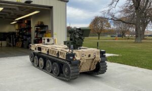
The Army has already begun to integrate OWT in its two parallel efforts to develop new Robotic Combat Vehicles (RCV): RCV (Medium) and RCV (Light), Parsons said.
“They are using One World Terrain in their initial experimentation studies,” he said, with the goal being for all future vehicles to be so equipped.
QinetiQ North America, and its partner Pratt Miller Defense delivered a quartet of seven-ton RCV (Light) vehicles to the Army this past November and December. The Army’s Combat Capabilities Development Command (DEVCOM) Ground Vehicle Systems Center (GVSC) at the Detroit Arsenal, Michigan, in May took delivery of the last of four RCV (Medium) prototypes. RCV (Medium) is built by Textron Systems, with partner Howe&Howe, and is based on Textron’s 10-plus-ton Ripsaw mini-tank.
Brig. Gen. William Glaser told the AUSA audience Oct. 12 that the Army is working with the other services as it evaluates the potential operational uses of OWT — including for use in the Pentagon’s wider Joint All Domain Command and Control (JADC2) of all-domain operations around the globe.
“We’ve actually talked to many of our joint partners,” Glaser said in response to a question from Breaking Defense. “The fact is that they’ve seen the potential that One World Terrain has.”
For example, he noted during the press conference later, an OWT-generated map of Hamid Karzai International Airport, in Kabul, Afghanistan, was used by the 82nd Airborne Division during the evacuation of US citizens.
Glaser said that his team is “actually very proud of that product, because it really just started off as an idea within the simulations community, but it’s expanded out significantly into the operational community.”
“When we can converge the training and operational community into one, that’s very clearly a win,” he said.