WASHINGTON: While civilian uses of infrared satellites such as wildfire monitoring and drought prediction are well known, startup Hydrosat is working to convince military customers that the ability to detect and map tiny temperature differentials from space also has a number of battlefield uses.
And the military appears interested, having awarded Hydrosat three Small Business Innovation Research (SBIR) contracts — even though the DC-based company has yet to orbit a single satellite, CEO Pieter Fossel told Breaking Defense.
Air Force and Defense Department customers are primarily interested in the tech’s “temperature anomaly applications,” he said, for everything from mission planning to maritime monitoring. The three SBIR contracts included a Phase 1 and Phase 2 SBIR via the Air Force’s innovation hub AFWERX, and one with DoD’s National Security Innovation Network.
“We’re in the process of working with another Air Force customer on a new project using the same camera system,” Fossel added.
RELATED: Space Force to loft 2 new ‘neighborhood watch’ sats, as leader frets launch funds
Under the two Air Force SBIR contracts, worth some $800,000 in total, Hydrosat last year demonstrated that its IR camera, flying on a stratospheric balloon, could take thermal imagery to map where dry ground was likely to create dangerous “brown outs” that could imperil Air Force Special Operations helicopter pilots attempting to land.
3D vision is redefining how drones navigate without GPS
As “dirty” RF and contested environments proliferate, autonomy increasingly depends on resilient positioning.
“If you have really dry, loose soil, a helicopter’s going to come in, kick up dust … and then that’s going to have operational implications,” Fossel said, including potential loss of life. “So that contract was focused on using our infrared satellite data and analytics to help address that problem, help better assess landing zones in the planning phases of an operation.”
Dryer land, he explained, is hotter than damper land; land with vegetation is cooler than arid land with sparse plant life. “The true soil moisture of an area … has big implications for preparing the battlespace, and so that’s where a lot of the defense interest in in our company has come from,” he said.
RELATED: NRO contracts 5 commercial SAR firms for study, considers official acquisition
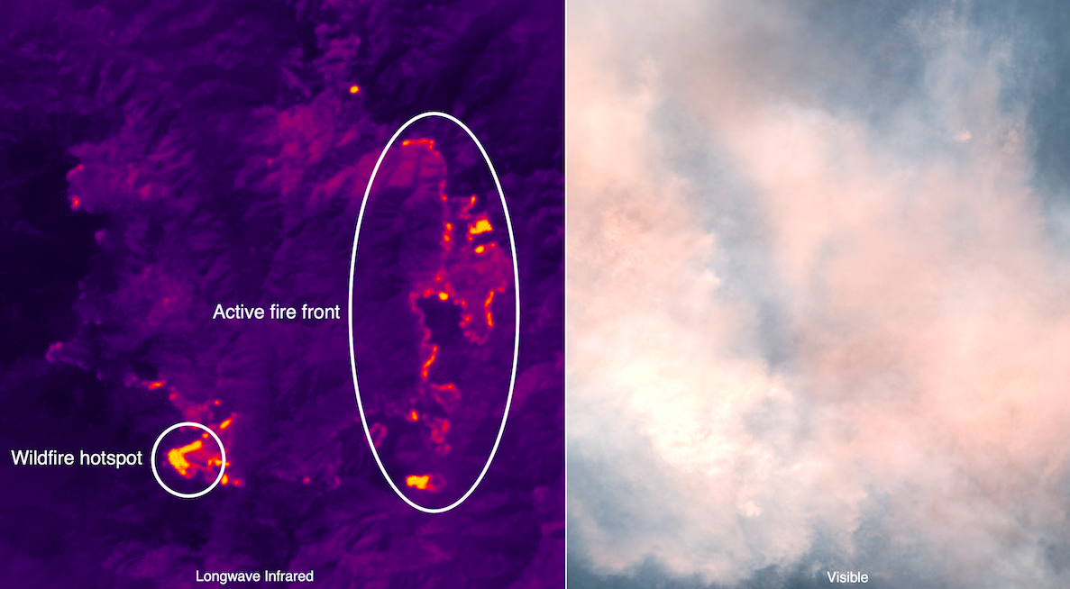
Hydrosat’s camera can differentiate a temperature differential of 0.5 Kelvin — which is more than enough to find ships running “dark” without their required identification transponders switched on, or a column of tanks moving at night, he added. (IR cameras, unlike electro-optical cameras, can image at night. Indeed they are often more efficient at night since the ground cools then and hot things show up brighter.)
Hydrosat intends to launch its first satellite, which is now being manufactured, on a SpaceX Falcon 9 via ride-share company Loft Orbital, early next year, Fossel said. The firm plans to station at least 16 satellites in sun-synchronous orbits at about 529 kilometers in altitude to provide global coverage, imaging the same spot on Earth at the same local time every day. The cameras will be able to “see” a 185 kilometer swath of ground using a “push broom” sweeping technique, so that they don’t have to be specially tasked to a target.
While there are other IR satellites in Low Earth Orbit such as NASA’s Landsat, Fossel says the company’s self-designed camera has a much higher resolution than current birds (not counting, of course, US spy sats) — about five times that of NASA’s newest Landsat-9. And there are no other companies using LEO IR sats to map temperature for commercial purposes, he stressed.
Further, Hyrdrosat already is offering such temperature maps using Landsat and other available IR imagery such as from the European Space Agency’s Sentinel-2.
“At a high level, Hydroset is a commercial infrared data analytics company,” Fossel said.