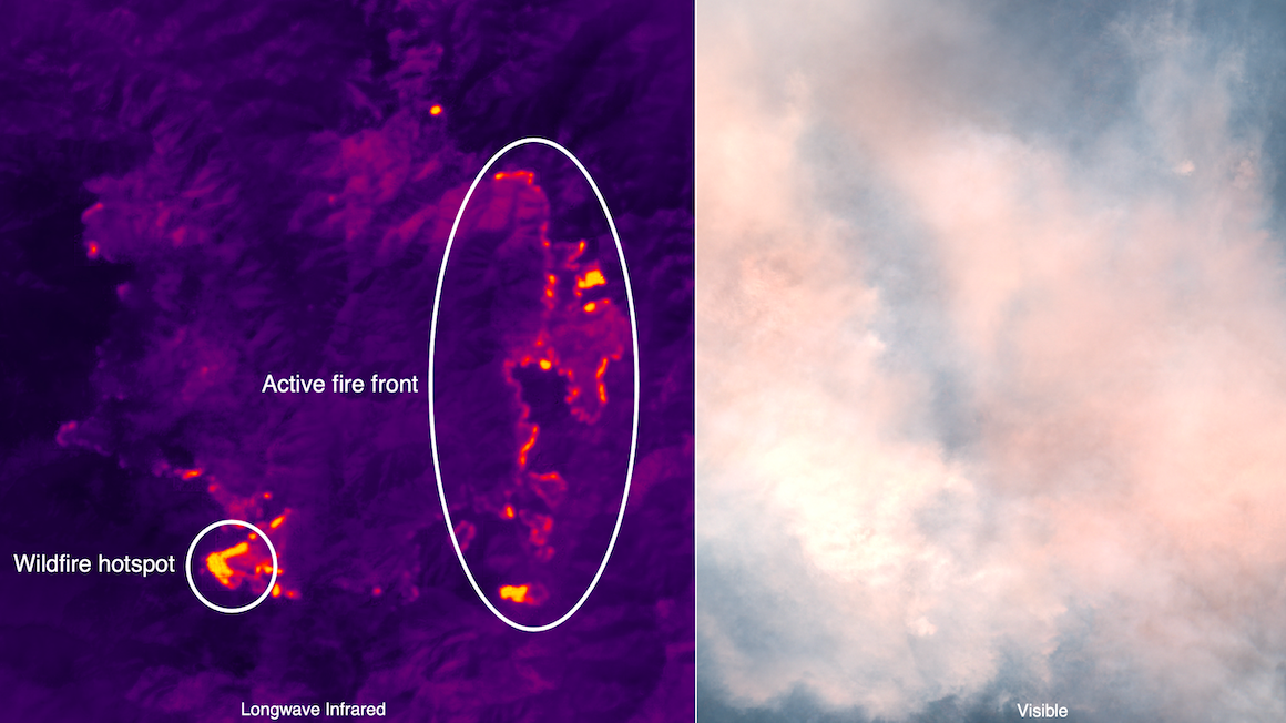
Hydrosat uses IR imagery to detect heat signature differentials for a number of military and commercial uses. (Hydrosat image)
WASHINGTON — The Air Force’s National Air and Space Intelligence Center (NASIC) has issued a new $1.2 million contract to study the potential value of startup Hydrosat’s satellite data, which measures temperature fluctuations on the Earth’s surface, for intelligence-gathering missions.
“The ultimate product, the ultimate value capability, that we’re delivering is that consistent, high accuracy, land surface temperature data set that can be used regardless of where the source imagery is coming from … for a variety of applications,” Hydrosat CEO Pieter Fossel told Breaking Defense today.
“Obviously, our core business focus is water stress — irrigation related applications, environmental and climate change applications — but it can also be used by NASIC and other US government customers, as they look at temperature anomalies over time, in various areas of interest that they may have,” he explained.
While civilian uses of infrared satellites such as wildfire monitoring and drought prediction are well known, military interest is relatively new. Air Force and Defense Department customers are primarily interested in the tech’s temperature anomaly applications, for everything from mission planning to maritime monitoring.
Fossel noted that the NASIC agreement follows a series of previous SBIR contracts from AFWERX over the past couple of years to demonstrate Hydrosat’s capabilities. In particular, one demonstration was designed to show how thermal imagery can map where dry ground was likely to create dangerous “brown outs” that could imperil Air Force Special Operations helicopter pilots attempting to land.
The “direct to Phase II” Small Business Innovation Research (SBIR) contract was brokered by the service’s AFWERX innovation hub, and will allow the remote sensing boffins at NASIC to play with Hydrosat’s data over an 18-month period. The goal: to see how it might be adapted and integrated with NASIC’s own systems for fusing remote sensing data and providing intelligence, surveillance and reconnaissance products to Air Force commanders.
“We have a data fusion capability. It’s actually one of the core competencies of Hydrosat, where we take open Earth observation data from many different sources, but a lot from NASA and from the European Space Agency, and we run that data through data fusion algorithms that we’ve developed inside Hydrosat to produce our own higher resolution daily surface temperature product,” Fossel elaborated.
Data gathered over time and processed can be tailored for individual customers and their area of interest, via a subscription service, he explained.
“We’re trying to enable a business model that doesn’t require a customer to pick up the phone and buy every single image, but allows us to deliver images — historically, but also into the future — over time over that area of interest in a efficient and affordable way, so that they can truly get the most value out of out of the data set,” Fossel said.
While the company currently is using already available data from satellites like NASA’s Landsat and ESA’s Sentinel-2, Hydrosat also intends to launch its own constellation of 16 microsats to low Earth orbit (LEO).
“We have two different payloads. We have our long wave infrared payload that’s providing the thermal data for temperature, anomaly detection, and measurement. We also have a seven-channel multispectral payload so visible to near-infrared, and that’s a little bit smaller,” Fossel said.
The first satellite, called VanZyl-1, has been completed using a bus provided by Loft Orbital, and is set to fly on a SpaceX Falcon 9 this year. A second bird is now under construction, he added.
Air Force picks Anduril, General Atomics for next round of CCA work
The two vendors emerged successful from an original pool of five and are expected to carry their drone designs through a prototyping phase that will build and test aircraft.

