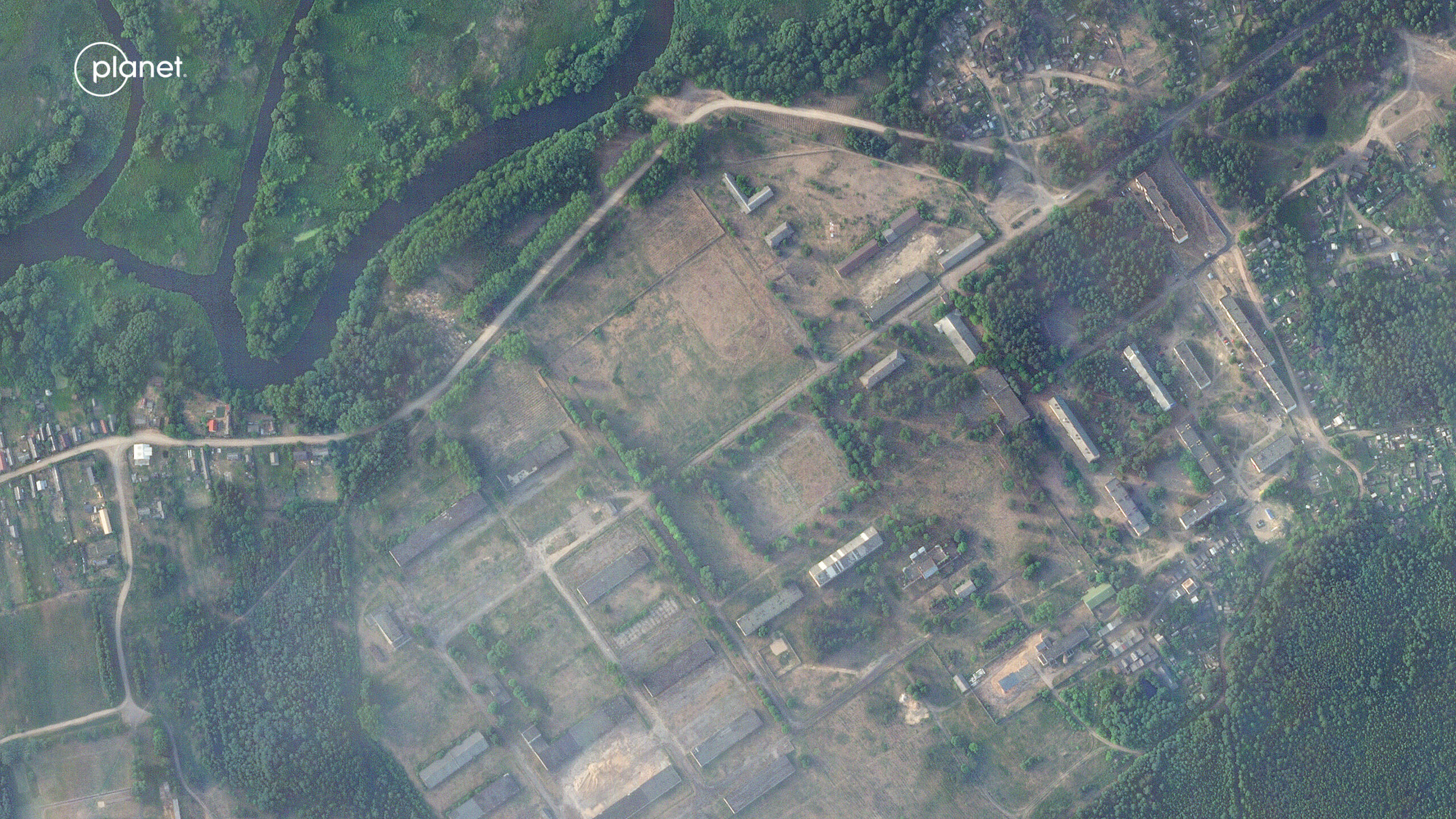
Planet’s satellites capture a military field camp taking shape in Belarus, which analysts say housed the Wagner Group. The camp has since been dismantled following Wagner Group leader, Prigozhin’s, death. Image courtesy of Planet Labs.
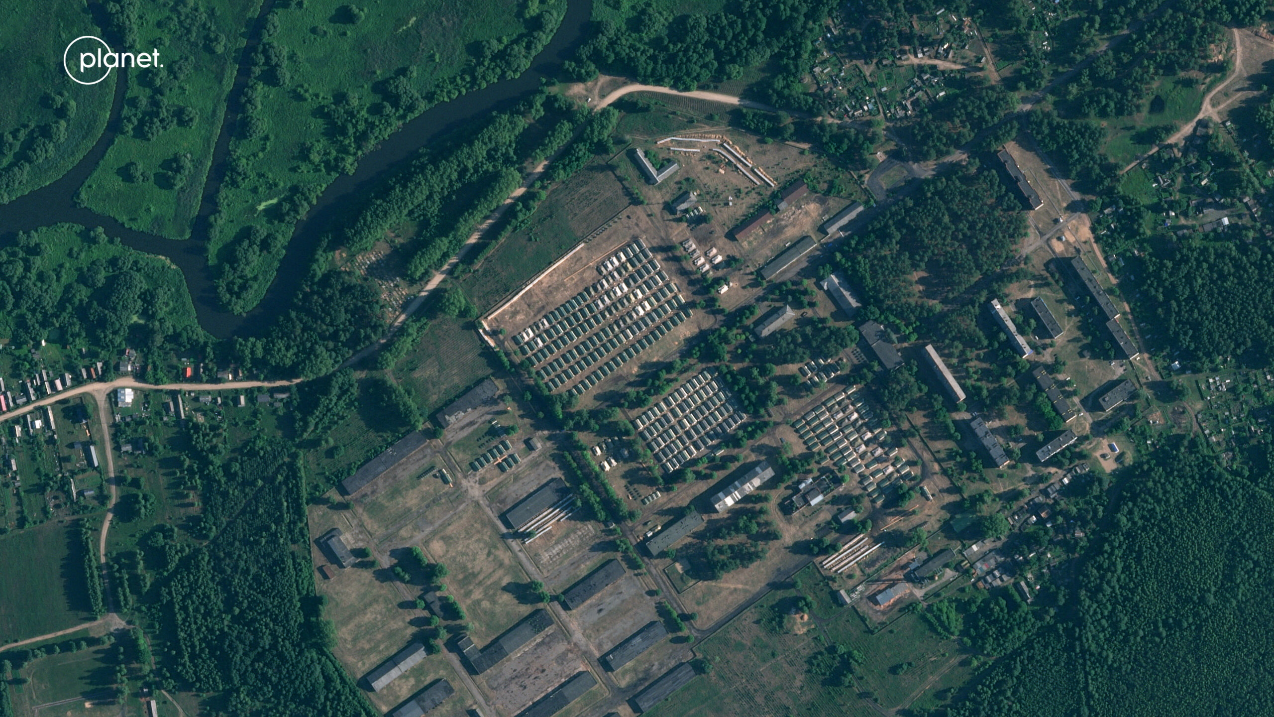
Image courtesy of Planet Labs PBC.
In this Q&A with Jim Thomason, vice president, Imagery and Analytics for Planet, a provider of global satellite imagery and geospatial solutions that image all of the world’s landmass every day, we discuss: the company’s roots as a CubeSat pioneer; its two constellations totaling roughly 200 imaging satellites; and how it’s newest satellite called Tanager will sense in 400 spectral bands.
Breaking Defense: Tell me about the founding of Planet and the company mission?

Jim Thomason, vice president, Imagery and Analytics for Planet.
Thomason: Planet was originally founded by NASA scientists working on various R&D missions who came to the realization that the phones in their pockets were as highly capable as many sensors that cost them millions of dollars to send to space. It spawned the idea of taking what’s happening in commercial and consumer electronics to make space more accessible, more democratized, and more usable for a broader audience outside the realm of classified government work, while at the same time being more shareable by those government customers.
Planet was able to put enough technology into this very small form factor to make it a scientific-grade instrument. That was huge, with the first five years of Planet proving that could be true, that we could take what was costing hundreds of millions of dollars in government programs and make it a commercial business where we could put very capable technology into a small form factor that had redundancy in the design of our overall fleet.
Instead of having a team of people working on one mission, one satellite, one spacecraft, we had hundreds of satellites with just a handful of people to watch over them. It shifted the whole paradigm, massively taking advantage of Moore’s Law and how more and more capabilities can be kept in the same volume, same mass from years ago.
Those were our first Dove CubeSats, which were initially launched in 2013; today we are 16, 17 generations of Dove satellites later.
Breaking Defense: Describe Dove and your other platforms and sensing capabilities.
Thomason: We currently have two main classes of satellites in space. The first are the Dove cubesats that I mentioned. They’ve come a long way and are now SuperDoves with 180 in operation. They are in a sun synchronous orbit and their mission is to image anytime they’re over land and some parts of the ocean.
Because we have so many of them, they take a full scan of the landmass of the Earth every day. They’ve been doing that for six years, which means that we have an image of any point on Earth at least 2,400 times or more.
Their resolution is three-to-four-meter pixel resolution so you’re seeing things like ships, buildings, and land cover – agriculture, forests, urban, all these different land cover classes that our customers care about. They can see those clearly in that full scan of the Earth.
The SuperDoves are complemented by our second class of spacecraft, SkySats. Those are what’s called ‘tasked mission,” meaning that they don’t image everywhere every day, but they can image anywhere every day, actually multiple times a day.
These are high-resolution satellites. Instead of that three-to-four-meter resolution, these are 50 centimeter resolution. Every pixel is a foot and a half. What that means is now you can see things like cars, more detail about what kind of ship you’re looking at, or even count rows of crops or trees.
We have 20 SkySats; they’re in both sun synchronous orbit and inclined orbits so that they can then revisit a specific point on Earth multiple times. When you put those two capabilities together you have this great opportunity for tip and cue.
I can look for interesting change in that global scan such as increased activity around a port. Or maybe I see a big swath of forests that someone cut a road into. I can then cue up a SkySat to look at specific changes, vehicles, and events on the ground. The complementary capability between our global scan and reliable all-the-time-access to high-resolution task imagery is an excellent combination.
Going forward, we want to keep building cool stuff and future missions are being built now and launching soon. The Pelican satellite is our next generation of high-resolution satellites and is going to be taskable like a SkySat but super responsive, meaning that we can put a task onboard in minutes and deliver imagery in less than an hour after we take it.
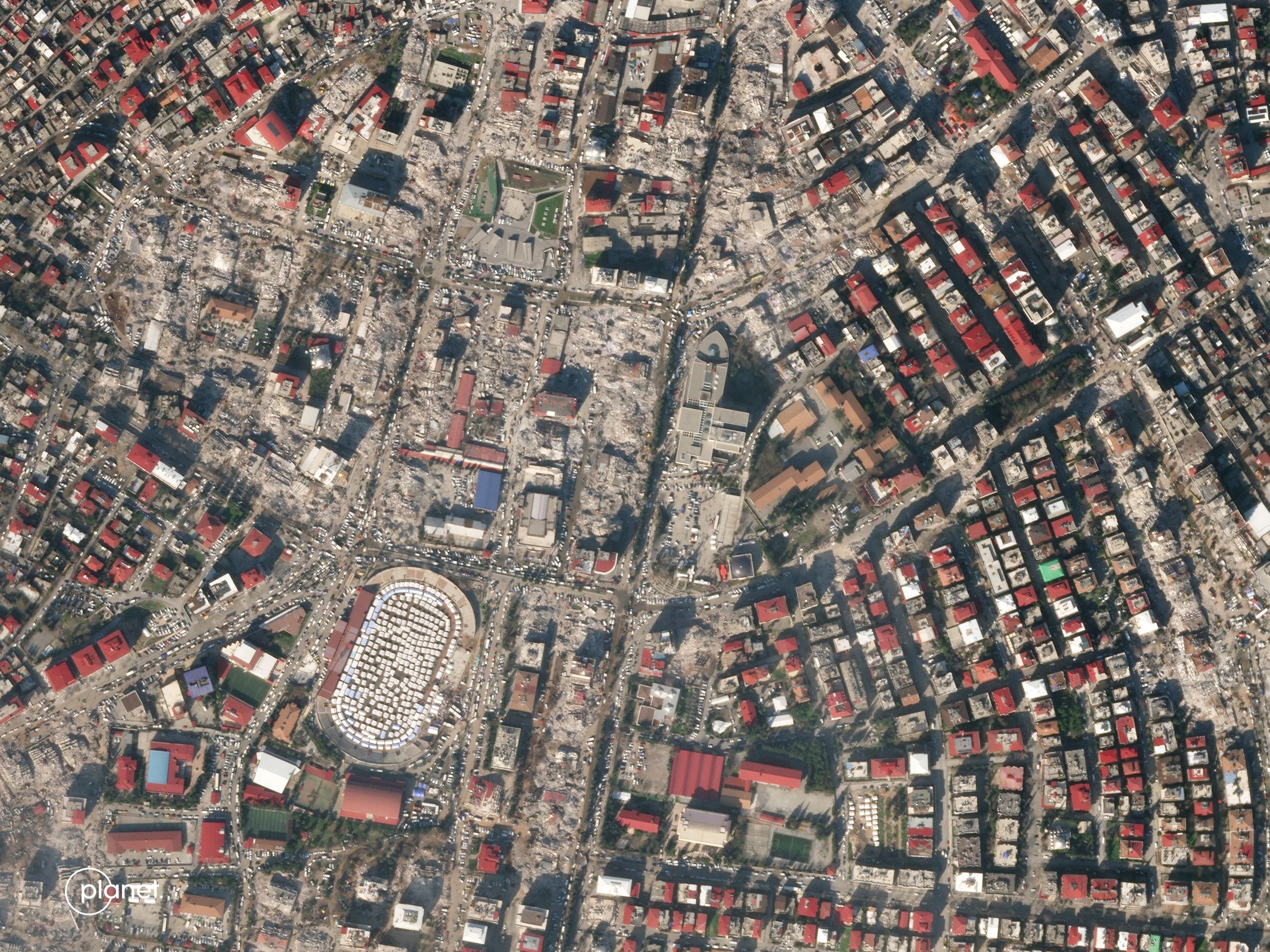
Planet satellite imagery shows widespread destruction in central Kahramanmaras, Turkey following the devastating earthquake that struck earlier this year. Image courtesy of Planet Labs PBC.
Breaking Defense: You’re also developing a new satellite with an even more advanced sensor named Tanager after the bird. Describe that.
Thomason: Our electro-optical sensors are looking in the visible through near infrared part of the spectrum. The SuperDove constellation is in eight spectral bands: Coastal Blue, Blue, Green, Second Green, Red, Red Edge, Near Infrared, and Yellow. We have four spectral bands on SkySat: Blue, Green, Red, and Near Infrared, plus a panchromatic sensor as well.
Tanager is going to be a hyperspectral sensor, which will image in a broader part of the electromagnetic spectrum. We’re going from 400 nanometer to 2,500 nanometers with 5 nanometer spacing. Instead of 8 spectral bands, we have over 400 spectral bands. Tanagers are birds of many bright colors and because we have 400 different colors on the satellite we choose to name it after a very colorful species of bird.
Breaking Defense: That was the ‘sense’ part of the discussion, let’s talk about how Planet is using AI/ML tools to unlock the power of the E/O data that SuperDove and SkySat are collecting?
Thomason: We own 200 satellites and are collecting a massive amount of data. We downlink well over 30 terabytes of data every day. Our full archive is over 50 petabytes of data. It’s an amazingly rich resource that can be, as you can imagine, a challenge to filter through and search and find. The introduction of AI/ML is great for our customers because they now have a tool that can help them search through that archive and can find all the various needles in the haystack. You can find some bespoke thing in Planet’s imagery today, and then go back through that 50 petabyte archive and find those patterns through time.
The AI models that you hear so much about today such as these large language models like ChatGPT are data hungry. They want more and more data and they’re crawling the Internet in order to learn and get smart. At Planet, we have this massive geospatial data archive that creates a huge opportunity for our customers to bring their data-hungry models to this Big Data treasure trove.
In addition, we have a whole ecosystem of partners who specialize in either industries or technology where we can leverage our data plus their capabilities to deliver unique solutions to customers. One example of this was with our partner Synthetaic, who you may remember as the company that identified the Chinese spy balloon earlier this year.
Before that happened, we looked across the whole of China for Synthetaic at almost 10 million square kilometers and were able to find airfields, ports, missile silos, all these things. We used our SkySat imagery to zoom in on specific airfields and look through time to see different kinds of aircraft.
Through AI/ML we were able to do that in minutes versus days or weeks of analyst time. It was an amazing opportunity to let those analysts collaborate with our data, and collaborate with tools that are built on top of this AI capabilities so that it just wildly expands that analyst’s ability to look through our data to find what is interesting to them and to track things they’ve never been able to in the past.
Breaking Defense: Connect that back to the warfighter? Why does it mean for someone on an aircraft carrier in the Indo-Pacific or an Army soldier operating a Patriot missile battery in Poland?
Thomason: It’s about having awareness anywhere in the world, especially for deployed warfighters that need as much visibility as they can get into the theater where they’re operating. You don’t want them to have dated information; you want them to have the latest information.
We also want them to be able to share that information with their mission partners so that they’re all working from a common playbook. They can share Planet’s data openly and in a way that they can’t with their national assets. That transparency and the freshness of the data and the insights it has are things that are of great value to our customers and the government within the defense space.
Breaking Defense: How is this data shareable among services for application in Joint All Domain Command and Control and all-domain operations?
Thomason: Our contracts with the NRO [National Reconnaissance Office] through the EOCL [Electro-Optical Commercial Layer] program define those licenses. We license our data in order to make it shareable between different agencies and user groups within the government. The intent of that license within the EOCL contract is to make it more shareable.
For us, it’s about meeting the real need of the customer and end user. Transparency is a hugely valuable thing, especially for our defense customers. It’s because they’re able to share that they can raise transparency and help to keep us out of a Cold War dynamic where it was the lack of transparency that caused escalation.
The ability to share, to bring transparency between agencies and even countries is something that’s hugely important for Planet.
Breaking Defense: Final thoughts?
Thomason: Planet has several differentiators worth noting. One is our overall coverage. There’s no one else in the world that is imaging the entire Earth at a daily cadence. That capability alone is quite a differentiator.
We feed these AI models in a way that no one else can. If you find something in Canada that is interesting to you, there’s no one else in the world that can show you that point in Canada on any given day three or four years ago. We can find it, we can rewind the image of the Earth back for years and we can look anywhere in the world. That coverage is a huge differentiator for us.
We’ve also pioneered the ability to deliver time series of information. Historically, satellite imagery has been about gleaning as much detail as you can from one image that you have. At Planet we now like to think in a time dimension, as well. It’s not just about what I can tell you about this one image, it’s about what I can tell you about this series of images through time in that one location.
The last dimension is spectral resolution. This is where we’re moving the needle with the combination of our eight-band SuperDove and our upcoming 400-band Tanager. We can now give you the spatial, temporal, and now spectral resolution to find interesting things – whether it be identifying unique kinds of material signatures or looking at the Earth in a way that we’ve never been able to in the past, now that we have this new spectral richness in our Tanager data.
Putting all of that together, integrating all of those capabilities into one archive and one catalog, there’s no one else who can offer that richness of data. Again, this is why machine learning/AI model development on top of our archive of data is such a huge opportunity for our partners.


