
Europe stands at a defining moment for sovereign intelligence. The next disruption—whether driven by adversarial aggression, cyberattack, supply chain pressure, or natural disaster—will test more than the ability to collect information. It will test whether nations and coalitions can understand what is happening in real time, share that understanding securely, and act before conditions change.
That requirement is moving space-based intelligence from a specialized capability to a core element of national resilience. Satellites help governments monitor military activity, track threats across borders, support disaster response, and protect critical infrastructure. Paired with aerial systems and ground-based data, they can create a constantly updated view of the physical world.
But more sensors do not automatically produce more clarity. Across defense, security, logistics, and infrastructure, organizations are managing enormous volumes of data from systems that were not designed to work together. The result is a familiar gap: the data exists, but the operational picture does not.
Sovereignty depends on the system, not just the hardware
Many sovereign space strategies still begin at the sensor layer. The logic is understandable: if a nation owns the satellite, it controls the data. If it controls the data, it controls the outcome.
Sovereign sensors matter. They provide assured access, reduce dependency, and give governments a level of control that was not possible a decade ago. But modern intelligence is inherently multi-source. Each sensor captures only part of the picture. Electro-optical imagery, synthetic aperture radar data, drone feeds, and ground-based signals can each be accurate while still failing to produce a shared understanding.
If those inputs cannot be aligned quickly, commanders and operators are left reconciling fragments instead of acting on a trusted view of reality. In a contested environment, that delay is not administrative. It is operational.
Ukraine shows what speed and integration can deliver
Ukraine has shown how quickly commercial capabilities can be integrated into sovereign warfighting solutions when operational speed is the priority.
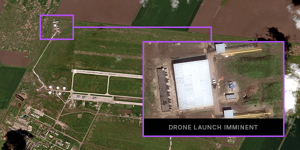
Vantor has deployed an integrated space-based intelligence system that gives Ukrainian troops on the frontline the ability to directly task high-resolution electro-optical and synthetic aperture radar imagery, helping soldiers identify targets and coordinate drone operations with greater speed and precision. Bringing geospatial intelligence directly to the frontline gives units the ability to understand, act, and respond at decisive speed.
That model matters for Europe. Building space hardware takes years, but operational requirements do not wait. Nations that can integrate commercial and national capabilities into sovereign intelligence architectures today can deploy earlier, adapt faster, and maintain continuity as their hardware infrastructure matures.
Commanding the ground truth requires the full stack
This is where integrated spatial intelligence becomes essential. Sovereignty does not come from adding another data feed, sensor, or analytics tool into disconnected workflows. It comes from having the infrastructure to turn trusted sources into one operational picture, and the tools to control that process from tasking through delivery.
Vantor provides that infrastructure. Its spatial intelligence capabilities give nations and partners the foundation, platform, and AI-powered tools needed to build and operate sovereign intelligence systems.
It starts with secure, local access to a highly accurate 2D and 3D spatial foundation: a living model of the Earth that allows satellite imagery, radar data, drone feeds, and other sources to be aligned to a common reference point.
From there, Vantor’s end-to-end platform gives nations the software tools to orchestrate the intelligence cycle across sovereign and commercial sensors. Users can keep their operational picture current, apply AI to accelerate analysis, and deliver finished intelligence wherever it is needed — all within a private, secure sovereign environment. That means commercial capability can be integrated without giving up control of the data or the mission architecture.
The result is intelligence that can move at operational speed. When these capabilities operate together, spatial intelligence becomes the infrastructure for command: connecting sensors, systems, operators, and machines to the same trusted view of reality.
From collection advantage to decision advantage
Europe’s security requirements demand a shift from asset-centric thinking to system-centric capability. The question is no longer simply who owns the most sensors. It is who can bring sovereign and commercial inputs together into an architecture that delivers clarity, speed, and control when it matters most.
That is the foundation of modern sovereignty. Not isolation from commercial capability, but command over the system that turns every trusted source into operational advantage.
Learn more about how integrated spatial intelligence can help build sovereign decision advantage.