
Commercial remote sensing: The critical U.S. National Security Space imperative
Accelerating space-based intelligence — the most critical domain in modern warfare — at disruptive speed and economics.
Accelerating space-based intelligence — the most critical domain in modern warfare — at disruptive speed and economics.

Success of each mission depends on advanced technologies, automation and flexibility.

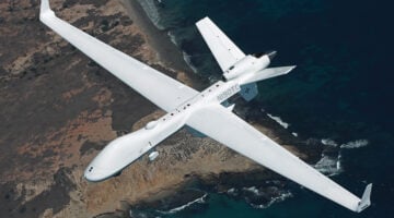
The MQ-9B and Gambit Series represent parallel capabilities that address global challenges for security head-on.
Gary Blohm, director of the Army Geospatial Center, said 3D is important to troop training and to operational planning because it "helps us navigate, especially when we get to urban environments."

The RFI explains that SDA is looking to potential contractors to supply "concepts for rapid prototyping, risk-reduction efforts that could be demonstrated in less than 18 months" that link to its proposed architecture.

Newly proposed licensing rules for commercial remote sensing will eliminate automatic DoD review rights for of a majority of applications.

"Security in space is different than security on Earth," says Jeb Linton of IBM Watson. "If you lose command and control for even five minutes, your satellite could be completely shut down."


Balancing security and access to data are critical to providing users with trustworthy, reliable data for real-time decisions.