UPDATED with Sen. McCain & Dean Cheng comments
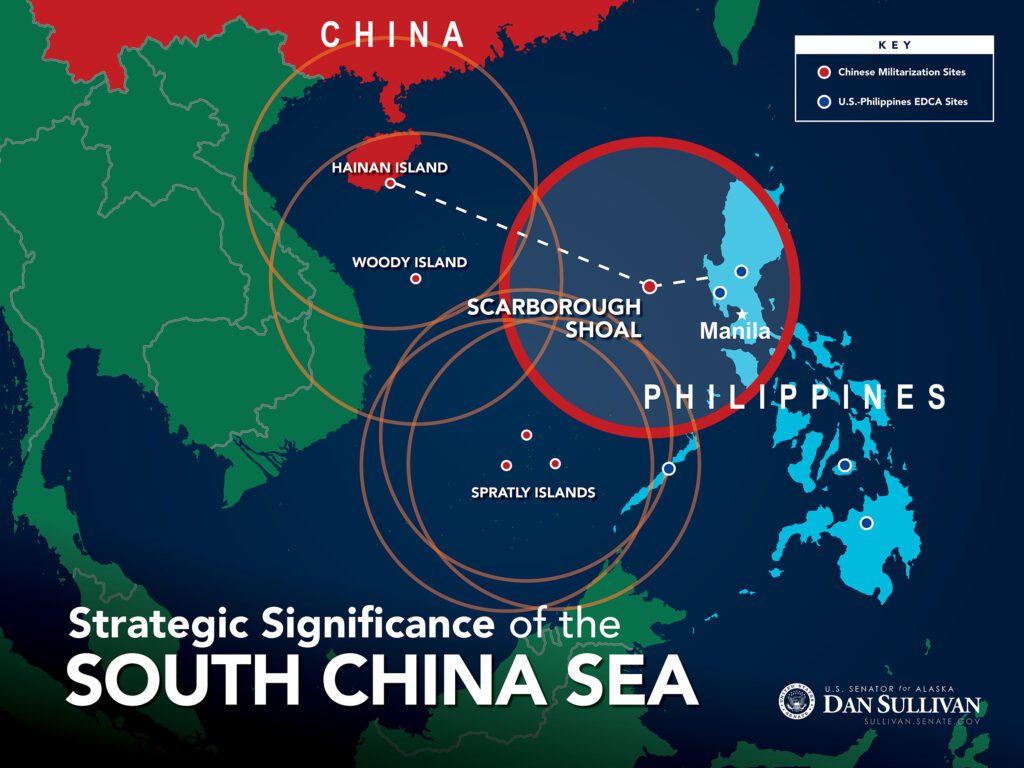
WASHINGTON: If China builds an artificial island on the disputed Scarborough Shoal, Sen. Dan Sullivan warned today, it will complete a “strategic triangle” of bases that can dominate the South China Sea. At this morning’s Senate Armed Services Committee hearing, Sullivan displayed a map (above) of the region overlaid with the ranges of Chinese fighters striking from a triangle of bases on (1) the Chinese island of Hainan, (2) the disputed Spratly Islands, and (3) Scarborough Shoal (as yet unbuilt). The overlapping rings would cover not only almost all the South China Sea, but much of the Philippines and Vietnam.

“Your map’s absolutely accurate,” responded Defense Secretary Ashton Carter. China’s actions are “deeply disturbing to countries in region, which has them all coming to us….We are being increasingly invited to work with countries,” from old allies like Australia, Japan, and the Philippines to new partners like India and Vietnam.
Vietnam has agreed to allow the US Army to preposition equipment for humanitarian responses, in itself a major shift by Hanoi, which has fought multiple wars and skirmishes with its giant neighbor, China. As Sullivan’s diagram shows, almost all of Vietnam is in range of existing Chinese bases.
The US has also expanded its long-standing but often-strained relationship with the Philippines. Under a new Enhanced Defense Cooperation Agreement (EDCA), the two countries announced in March that US forces would have access to five military bases across the country. But as Sullivan’s map makes clear, two of those five bases would be in range of Scarborough-based Chinese fighter-bombers, as would the capital city of Manila.

Shaping the future of airpower in the Indo-Pacific: GA-ASI’s revolutionary approach
General Atomics Aeronautical Systems, Inc. (GA-ASI) has been the trailblazer in the UAS revolution for over three decades.
“Senator Sullivan is right,” said Greg Poling, director of the much-cited Asia Maritime Transparency Initiative (AMTI) at the Center for Strategic and International Studies. “If China built an artificial island and military base at Scarborough, as it has in the Spratlys and Paracels, it would bring the entire South China Sea within Chinese radar, air, and eventually missile coverage. It would also bing much of the Philippines, including Manila, Clark (air base), Subic (Bay), and at least two of the bases the US is getting access to under EDCA within that Chinese umbrella.”
So far, China hasn’t started work on Scarborough, Poling and his CSIS colleague Bonnie Glaser agreed. “In the (satellite) imagery that we have obtained from DigitalGlobe, we have not seen anything,” Glaser told me. That said, given the limits of commercial imagery, she added, “we are not monitoring this 24-7, of course.”

The Chinese are allegedly more active in the region. Chief of Naval Operations Adm. Jonathan Richardson has described “survey type of activity,” there are rumors of dredging vessels in the area (though not at the Shoal itself), and Philippine papers reporting more Chinese Coast Guard vessels, historically far more aggressive than their Chinese navy counterparts. In response, US aircraft have stepped up patrols of the area, including land-based A-10 attack planes flying from the Philippines.
There are also strong signals from unnamed sources and websites associated with Beijing that China will begin reclamation. Glaser, however, is skeptical. One People’s Liberation Army officer “with stars on their shoulders” told her island-building on Scarborough is “very, very unlikely,” because Beijing is well aware how badly the region would react. Such action would blatantly violate both China’s 2015 pledge to cease island-building and its 2002 Declaration of Conduct with the Association of South East Asian Nations (ASEAN). China has broken both promises before, but never so egregiously as building on Scarborough would be.
“A resumption of land reclamation after stating they would stop would make the rest of the region very, very nervous,” Glaser said. “It would also be a signal, not only to the region, but also to the rest of the world that China is going to flout international law.”
Dean Cheng, of the conservative Heritage Foundation, is much more pessimistic. The “strategic triangle” is practically enshrined in Chinese law, he noted: In 2012, Beijing created the prefecture of Sansha, or “Three Sands,” to administer its claimed territories in the “South Sands,” i.e. the Spratlys; the “West Sands,” i.e. the Paracels; and the “Middle Sands,” i.e. Scarborough Reef, Mischief Reef, and other areas off the Philippines.
“The Chinese were telegraphing this years ago,” Cheng told me, and the US has put up only feeble resistance to Chinese land-grabs so far, so why would they stop? “Given how quickly the Chinese built the Spratlys, I say we’ve got maybe less than a year before the first runway gets built” on Scarborough, Cheng said.
If China did build an island, the second question would be what it built on the island. So far, high-end military capabilities like bomb-proof aircraft hangars and HQ-9 anti-aircraft batteries are restricted to the Paracel Islands, which are natural features off Vietnam, said Glaser. The artificial islands in the Spratlys have received advanced radar and runways, Poling said.
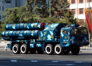
Long-range anti-aircraft missiles like the HQ-9 or the Russian-made S-400, combined with fighter jets, would dominate the airspace over the South China Sea, putting unarmed American P-3 and P-8 patrol aircraft at risk. Such missiles on Scarborough could fire right over Philippine territory into airspace off Taiwan. The Chinese will likely declare an Air Defense Identification Zone (ADIZ) over the South China Sea as they did over the East China Sea, Cheng said. Long-range anti-ship missiles could hold at risk the vast volume of commercial maritime trade that passes to and from the Strait of Malacca.
Putting offensive capabilities like long-range missiles on the islands would be “a very destabilizing move,” said Andrew Krepinevich, former president of the Center for Strategic and Budgetary Assessments. Such assets would be intimidating in a crisis, but so vulnerable in an actual shooting war that China would face the temptation to “use it or lose it.”
“Given the small size of the islands, the missiles would be highly vulnerable, as they could not rely on mobility or hardening to provide passive defense against attack,” said Krepinevich. “They are high-value assets that are also soft targets tethered to a very small area—the island they are on.”
“The deployment makes the most sense if you have a military doctrine that calls for striking first,” Krepinevich continued, “or if your principal purpose is not to fight, but to intimidate your much weaker neighbors in the absence of a serious effort by the United States.”
Certainly Senate Armed Services chairman John McCain doesn’t think the administration is sufficiently serious about taking a public stand against excessive Chinese claims. Frustrated with Defense Secretary Ash Carter’s repeated refusal to acknowledge recent South China Sea patrols, on the grounds they might be classified, McCain declared that “the fact that we are sending our ships and airplanes into international waters (is) classified, when it should be magnified throughout the world…is confusing and befuddling.”
A full-sized version of the Sen. Sullivan map is below.