


ICEYE image showing changes over time at Iraq’s Mosul Dam (ICEYE)
WASHINGTON: The Commerce Department is placing new restrictions for how frequently US-operated mid- to high-resolution commercial remote sensing satellites can image any one spot on the Earth, prompted by concerns from the Defense Department and Intelligence Community over the potential impacts of repeated captures of key US national security facilities.
The new restrictions, obtained by Breaking Defense and already piquing the fervor of critics in the sector, are being applied under the US commercial remote sensing licensing process managed by the National Oceanic and Atmospheric Administration (NOAA), which falls underneath Commerce. NOAA officials did not respond to Breaking Defense’s requests for comment.
The restrictions prohibit imaging of a list of areas where sensitive national security operations are taking place unless an operator fulfills certain conditions, including notifying NOAA 48 hours in advance to get a waiver. There also are restrictions on the duration of time imaging can be conducted on any one terrestrial “target.”
They will be applied to US remote sensing satellite constellations with the ability take repeat images — or “revisit rates,” in the industry jargon — of the same terrestrial location more often than their foreign competitors (or those of National Reconnaissance Office spy sats). The exact revisit rates and resolutions that would trigger the rule vary with the type of sensor being used.
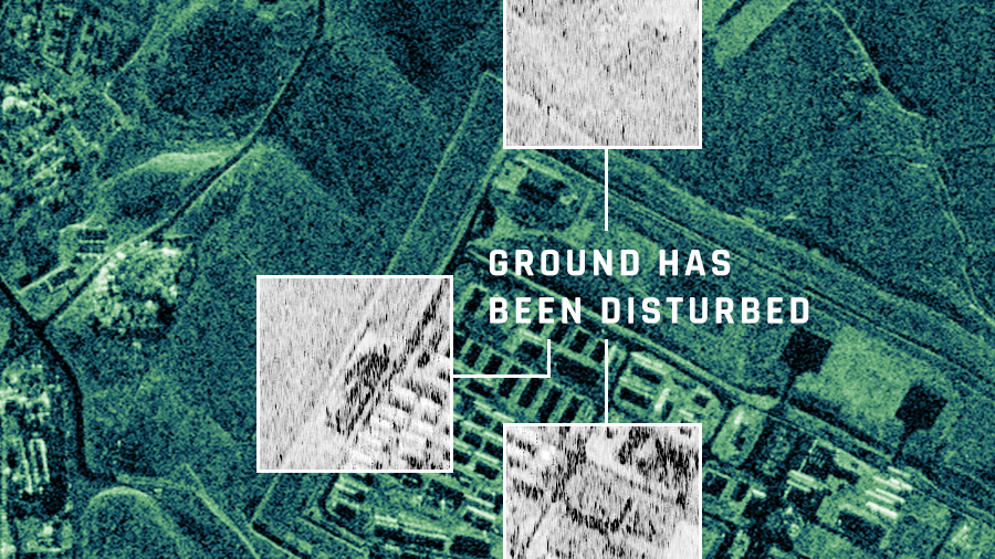
The concern is that high resolution rapid revisit imagery will reveal changes in activity patterns, known as change detection, at secret US facilities or, for example, troop movements during conflicts.
To implement the new rules, NOAA’s Commercial Remote Sensing Regulatory Affairs (CRSRA) office has created a new licensing category called “Rapid Revisit Imaging Systems” to capture systems breaking the benchmark thresholds. Such systems are deemed to fall under “Tier 3” of CRSRA’s three-tiered licensing scheme, which covers “novel” capabilities not available on the market.
The lowest level, Tier 1, covers US systems with capabilities already available on the international market and essentially results in an automatic license for unrestricted sales.) According to NOAA’s website, there are 61 such licenses in existence. Tier 2 covers constellations with capabilities available only in the US, for which NOAA reserves the right to include restrictions. Six Tier 2 licenses have been approved.
Under Tier 3, CRSRA can levy “temporary” restrictions on the commercial sale of all cutting-edge capabilities (not just revisit rates) at the request of the DoD and IC. According to the regulations, “temporary conditions will last only one year (generally starting from initial spacecraft operations).” The rules allow two one-year extensions of the constraints if the requesting department “meets a burden of proof, following review by Commerce and notification of licensees.” An extension beyond three years requires a request by the Secretary of Defense or State, and cannot be delegated to a less senior official.
Once every quarter, CRSRA provides operators with the parameters being used as benchmarks [PDF] for the tiering process. Those benchmarks cover resolutions for different types of sensor technology, revisit rates for those different sensors, persistence of imaging involved and a host of other technical factors.
Capella Space intends orbit a constellation of synthetic aperture radar (SAR) sats with a revisit rate of less than one hour — greater than the benchmark NOAA now applies for SAR revisit rates.
What is new is NOAA’s articulation of what restrictions apply to Tier 3 rapid revisit rates.
NOAA does not publicly provide the locations on the restricted list, called the Persistent Imaging Location List, as it changes over time. Industry sources, however, say it usually hovers between 60 and 70 places around the world. (While no one mentioned it, Area 51 — a highly classified Air Force facility located within the Nevada Test and Training Range, and a site fixated upon by UFO conspiracy theorists — is no doubt one such site.)
Specifically, the new CRSRA rule requires operators of a constellation deemed a Rapid Revisit Imaging System to comply with the following conditions:
A. The Licensee shall not image any location on the most recent version of the Persistent Imaging Location List provided by NOAA at a revisit rate more frequent than the most recent revisit rate benchmark provided by NOAA to the Licensee for the same phenomenology (or phenomenologies) and a similar spatial resolution, unless the Licensee:
(i) Provides imaging coordinates and start/stop times for each imaging period at each location to LMI@noaa.gov at least 48 hours prior to imaging;
(ii) Restricts imaging operations to a maximum of 25 minutes per any one-hour period; and
(iii) Does not image during more than three, one-hour periods during any 48-hour window.
Industry official: ‘It’s a big step backwards’
Unsurprisingly, the rapid revisit restrictions have sparked pushback from a number of remote sensing industry officials, who assert they are yet another example of the national security community trying to turn back the clock and claw back ground lost in the remote sensing regulatory reform effort undertaken by the Commerce Department under the Trump administration.
Industry officials further argue NOAA’s ruling will stifle the ability of US firms to claim a leading edge in the growing global market for near real-time imagery products. The use of sat imagery to track terrestrial change has long been in use by the US government and even commercial firms.
The ability to do so with ever increasing timeliness is what is new in the commercial market, and what is worrying DoD and IC officials is that those burgeoning capabilities mean there soon will be no place safe from prying satellite eyes.
“These restrictions would severely hurt commercial companies’ ability to operate high resolution constellations and is counter to the efforts of the past two years to make NOAA regs streamlined and enable US companies to compete internationally. This restriction is WORSE than it was previously — it’s a big step backwards,” one irate industry rep said in an email.
Another het-up company official said the ruling “flies in the face of everything from support to military operations to humanitarian missions in the aftermath of a natural disaster!”
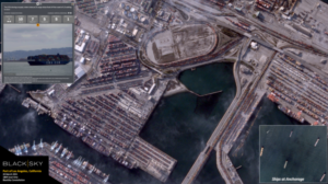
BlackSky image in color of the Port of Los Angeles. The company plans a revisit rate once an hour by 2024. NOAA has yet to determine a restricted revisit rate for multispectral images.
“These NOAA specs seem onerous,” an official from a third company said. This official emphasized that the notification condition about forewarning NOAA about imaging passes “seems like a nightmare” because it doesn’t provide a timeline for NOAA to respond as to whether it is okay for the operator to take the imagery involved. “Thus, it could drag on and leave the company hanging. And in this business, timeliness is everything.”
Still, a fourth industry source was more torn, saying the rule presents a classic “one one hand, on the other hand” situation.
On the up side, this source explained, “there was a time when this kind of situation, if presented to the government, would have gone into an unpredictable spiraling black hole and it could take more than a year before the operator would know when they operate under what circumstances and conditions etc.” So, in that sense, the Tier system used by NOAA “works” by providing more “operational clarity” that allows providers to plan.
On the down side, the source explained, the ruling is “not positioning” US industry to lead the global market. Rather it has “paved the road for the US to eventually be in second place on rapid revisit” as foreign companies are consistently moving faster than the government can recognize and respond in order to readjust controls to let US operators match up, much less overtake the competition.
The national security response
Several former and current government officials well-versed on the licensing process countered the industry concerns, noting that the NOAA’s current regulatory regime, promulgated in 2020 as part of the Trump reform push, was clear that some new capabilities would need to be constrained for limited periods based on IC best judgement.
Indeed, Stacey Dixon, deputy director of national intelligence, last month told the annual GEOINT Symposium exactly that. The Biden administration is “intensifying” work to reduce regulatory burdens on the commercial remote sensing industry where it can, she said, but “lifting some restrictions will not be possible, because custom and classified GEOINT capabilities are still critical to helping us understand and confront core national security challenges.”
“All temporary conditions are proposed by the Intelligence Community and the DoD and developed in coordination with the Department of Commerce as part of the regulatory process,” a spokesperson for the National Geospatial-Intelligence Agency (NGA) said in an email. NGA chairs the IC’s Commercial Space Council. “Temporary conditions only apply to data not currently available from a foreign source. Once those similar capabilities are available from a foreign competitor, the rule provides guidance for removing the temporary conditions from the licensed system.”
One former government official told Breaking Defense the new rules are not “egregious.”
“I think NOAA gave good solid answers,” the ex-official opined, noting NOAA’s rule shows that the new licensing process is working exactly as it is supposed to.
Further, a couple of other government and former government sources stressed that it is important to recognize the restrictions will apply only to imaging the areas of national security concern on the Persistent Imaging Location List, not the entire globe. These sources stressed that there simply are areas that the US government would rather not be publicly monitored with high fidelity.

Modernizing military simulation with open systems architecture
Best-of-breed common models and architecture enable virtual training and testing with the same data in a cyber-resilient posture.

‘Dead on arrival’: Key House appropriators oppose transfer of Guard units to Space Force
“The states need to be consulted, and need to be full partners moving forward in any major change such as this,” said Minnesota Rep. Betty McCollum, the defense subcommittee’s top Democrat.