WASHINGTON: Finnish startup ICEYE is partnering with the American Intelligence Community’s venture capital arm In-Q-Tel as US government demand for SAR satellite data skyrockets.
“We are now on contract with multiple customers, both on the defense and Intel side and on the civil side. We’ve had humbling reception, I would say, amongst all those sectors,” Eric Jensen, president of ICEYE US told me. “There is very clearly an unmet demand for complimentary commercial SAR here in the States.”
“ICEYE’s world-class SAR satellites and their market-leading global coverage allows for capture despite time of day and weather conditions. We are pleased and excited to bring this technology to our government partners,” Simon Davidson, managing partner, In-Q-Tel, and EVP, IQT Emerge, said in a press release yesterday announcing the partnership.
ICEYE also announced that it has built a US manufacturing plant in Irvine, Calif. to boost its satellite-making capacity to meet the rapid growth in its business base, but also to help bolster its bone-fides as a secure member of the US supply chain.
“It made the most sense to expand to the US, because we’re already partly serving the US market, but [also] in order to better serve the needs of our US customers,” ICEYE US CEO Jerry Welsh explained. “Obviously, there are some of those customers who would prefer to work with a US partner.”
The new facility is already starting to build spacecraft, he said, and has stood up a “24-7 spacecraft operation center,” a customer engagement center, and “all the things we need on the West Coast in Southern California, including our operations and our back office functions.”

Speed, AI, and the platform that makes it operational
These are the five root causes that account for most of the delay in cognitive operations staffing.
The company has a team already in DC, Welsh added, and is scouting out a Northern Virginia site to house, “a bit later this year,” a business development team, experts on its synthetic aperture radar tech, and a customer engagement center.
While neither Welsh nor Jensen would reveal their current US DoD/IC customers, the company has been collaborating since 2017 with DoD’s Defense Innovation Unit (DIU).
Further, the NRO is working to figure out how best to integrate commercial SAR-sat imagery into its developing ‘hybrid architecture’ for obtaining and using space-based intelligence, surveillance and reconnaissance (ISR) data. This includes opening its doors wider to commercial providers of electro-optical imagery, as well as exploring buys of SAR and other non-traditional sensing capabilities such as the use of radio frequency (RF) transmissions to track targets.
The National Geospatial-Intelligence Agency (NGA) also is working to develop a ‘hybrid’ pool of data that combines commercial imagery with low-resolution but high re-revisit rates with traditional high-resolution but less timely ISR data provided by the IC. It also intends to use commercially-provided geoint data to train artificial intelligence/machine learning programs to rapidly identify targets of interest.
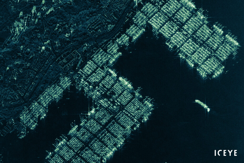
SAR satellites can ‘see’ through heavy cloud cover and in the dark, making them a key asset for enabling the IC and the military to track targets on the ground 24/7 — called ‘persistent monitoring’ in the tech community jargon.
ICEYE was the first commercial company to orbit a SAR satellite, and it now has launched 10 small birds, Welsh said, six of which comprise its current constellation delivering data to customers, and four of which were sold directly to customers for their private use.
“We’re targeting to launch another 10 satellites this year, three of which we launched already earlier in the year,” he said, noting that “some of those will be built here in the US.”
Currently, ICEYE’s constellation can provide SAR imagery down to “sub-one meter” in resolution, Welsh said. “It’s fair to say we’ll continue to improve from there, I’d actually say to sub-half meter.”